Bachelor Thesis topics
Disclaimer: this page is under construction.
Here you can find potential topics for a Bachelor thesis. Feel free to contact me.
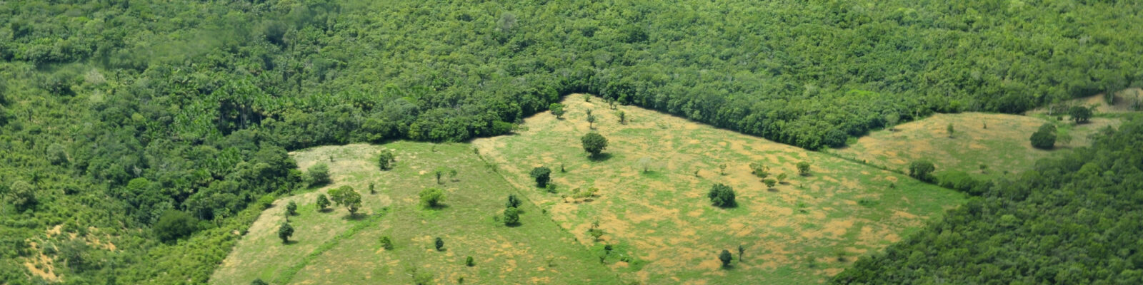
National parks and Anthromes
Where are the national parks located in Europe, and what is the relationship with anthropogenic biomes (or anthromes)? Focus on Natura 2000 areas, what does this mean for conservation?
Contact: dr. ir. Kees Klein Goldewijk (c.g.m.kleingoldewijk@uu.nl), VMA room 8.22
Note: requirements are that you at least have a basic knowledge of GIS.
References.
Klein Goldewijk, K., Beusen, A., Doelman, J. & Stehfest, E. (2017b) Anthropogenic land-use estimates for the Holocene – HYDE 3.2. Earth Syst. Sci. Data, 9, 927 – 953.
Ellis EC, Klein Goldewijk K, Beusen A (2020) Anthropogenic biomes: 10,000 BCE to 2015 CE. LAND 9.
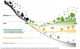
Bending the curve
The UN decade of restoration in combination with bending the curve on biodiversity? An analysis of which anthromes are most suitable for restoration and where can we find the most opportunities for biodiversity.
References.
Leclère D, Obersteiner M, Barrett M, Butchart SHM, Chaudhary A, De Palma A, DeClerck FAJ, Di Marco M, Doelman JC, Dürauer M, Freeman R, Harfoot M, Hasegawa T, Hellweg S, Hilbers JP, Hill SLL, Humpenöder F, Jennings N, Krisztin T, Mace GM, Ohashi H, Popp A, Purvis A, Schipper AM, Tabeau A, Valin H, van Meijl H, van Zeist W-J, Visconti P, Alkemade R, Almond R, Bunting G, Burgess ND, Cornell SE, Di Fulvio F, Ferrier S, Fritz S, Fujimori S, Grooten M, Harwood T, Havlík P, Herrero M, Hoskins AJ, Jung M, Kram T, Lotze-Campen H, Matsui T, Meyer C, Nel D, Newbold T, Schmidt-Traub G, Stehfest E, Strassburg BBN, van Vuuren DP, Ware C, Watson JEM, Wu W, Young L (2020) Bending the curve of terrestrial biodiversity needs an integrated strategy. Nature 585:551-556.
Ellis EC, Klein Goldewijk K, Beusen A (2020) Anthropogenic biomes: 10,000 BCE to 2015 CE. LAND 9.
Analysing historical land use with the PLUC model
The PCraster Land Use Change model (PLUC) is a python model build by Utrecht University. It is used in the Land Change Science course (3rd yr bachelor). It can model land use changes using suitability maps, demand, yield, and cartographic modelling operators. Your research will use the “PLUC model created for any country, edited for education” (Verstegen, 2018). The model requires a lot of data about the land use and present land features such as roads and rivers. The model recognises 4 land use types that will change: Urban, Cropland, Pasture, and Forest. Additional land use types can be added, but these do not have a demand nor yield, and thus cannot expand. The model considers 11 parameters that will explain the changes in land use: a demand and a yield, and 9 suitability factors. These suitability factors have weights that all add up to 1. Using this, the priority of specific suitability factors can be adjusted and suited to reality.
Important work is the making/creating of the necessary historical input maps for the PLUC model from existing sources, such as HYDE.
Your research aims to explore the PLUC model and will attempt to find whether it can accurately follow the same predictions as the IMAGE model (2020, 2021).
- Contact: dr. ir. Kees Klein Goldewijk (c.g.m.kleingoldewijk@uu.nl), VMA room 8.22
Note: requirements are that you at least have a basic knowledge of Python and GIS.
References.
IMAGE (2020). Welcome to IMAGE 3.0 Documentation. Retrieved from https://models.pbl.nl/image/index.php?title=Welcome_to_IMAGE_3.0_Documentation&oldid=33724.
IMAGE (2021). IMAGE framework/IMAGE 3.0 in a nutshell Retrieved from: https://models.pbl.nl/image/index.php/IMAGE_framework/IMAGE_3.0_in_a_nutshell#Features
Klein Goldewijk, K., A. Beusen, J.Doelman and E. Stehfest (2017), Retrieved from: Anthropogenic land use estimates for the Holocene; HYDE 3.2, Earth System Science Data, 9, 927-953.
PCRaster owners (2021). PCRaster documentation, command line applications, Mapattr. Retrieved from: https://pcraster.geo.uu.nl/pcraster/4.3.1/documentation/pcraster_manual/sphinx/app_mapattr.html#mapattr
Buiting, J. (2022) Exploration of the spatial-temporal capabilities of the PLUC model, bachelor thesis, UU.
Global historical land use: the importance of grazing land
As long as humans have been present on Earth, they have been altering the global landscape. These historical changes in land use, primarily conversion (deforestation) of undisturbed ecosystems to other forms of land use (cropland, grazing land), have contributed considerably to the cumulative increase in carbon dioxide (CO2) in the atmosphere. However, historical land-use change estimates are still very uncertain (Klein Goldewijk and Verburg, 2013). Therefore, there is a great demand for reducing the uncertainty in historical reconstruction of grazing lands, which then should be included in a consistent way in the land use reconstructions.
Important research questions are: How much land was used for grazing? Where did it take place? Was the land converted or just simply used (which is a very important distinction for the carbon cycle). Humans practiced very different grazing methods over time, from small scale herding in Roman and Medieval times, and todays Sub-Sahara Africa, to large scale ranging on marginal lands in North and South America and Central Asia, to deforestation of tropical forests in Brazil.
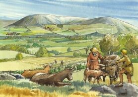 Medieval England
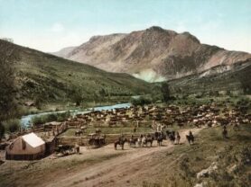
North America, 1898
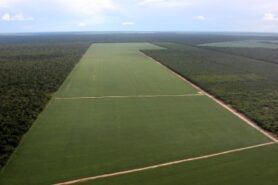 Brazil, 2005
The first goal is a literature study to create a database with historical information on livestock numbers and grazing area. The temporal focus covers in principle the Holocene period; the spatial focus can be either the global, regional or the country level (open for discussion). Results will be compared to and/or integrated in the HYDE database (Klein Goldewijk et al., 2017) which is used in many international research such as IPCC reports, the Global Carbon Project, PBL’s IMAGE framework (www.pbl.nl/image) and the Land Use Model Intercomparison Project – LUMIP, (Hurtt et al., 2020; Ma et al., 2020)).
Contact: dr. ir. Kees Klein Goldewijk (c.g.m.kleingoldewijk@uu.nl), VMA room 8.22
References.
Klein Goldewijk, K. & Verburg, P.H. (2013) Uncertainties in global-scale reconstructions of historical land use: an illustration using the HYDE data set. Landscape Ecology, 28, 861-877.
Klein Goldewijk, K., Dekker, S.C. & van Zanden, J.L. (2017a) Per-capita estimations of long-term historical land use and the consequences for global change research. Journal of Land Use Science, 12, 313-337.
Klein Goldewijk, K., Beusen, A., Doelman, J. & Stehfest, E. (2017b) Anthropogenic land-use estimates for the Holocene – HYDE 3.2. Earth Syst. Sci. Data, 9, 927 – 953.
Historical irrigation patterns
Irrigation intensifies land use by increasing crop yield but also impacts water resources. It affects water and energy balances and consequently the microclimate in irrigated regions. Therefore, knowledge of the extent of irrigated land is important for hydrological-, crop-, and integrated assessments modelling (IAM) in global change research. However, current historical global land use reconstructions such as the HYDE database (Klein Goldewijk et al., 2017) which supply directly input for those IAMs, don’t have irrigated areas in them. It should be included because of their importance for the geo-biochemical cycles, especially rice production, an important greenhouse gas emitting crop. Still, information on the historical evolution of irrigated lands is limited (Siebert et al., 2015). Therefore, there is a great demand for historical reconstruction of irrigation patterns. Important research questions are: How much land was irrigated? Where did it take place?
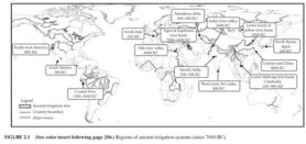 The first goal is a literature study to create a database with historical irrigation information. The temporal and spatial focus is open for discussion: in principle the Holocene period; and varying from the Euphrates/Tigris region, Egypt, India, China but also rest of Asia, the Americas and Europe, see figure 2.1.
Results should be checked against modelling efforts which focus on potential irrigation areas which are based on hydrology, topology, climate and soil conditions (research from dr. Rens van Beek (UU) for the Virtual Water Network of the Roman Empire, a project of Copernicus lead by dr. Brian Dermody).
Contact: dr. ir. Kees Klein Goldewijk (c.g.m.kleingoldewijk@uu.nl), Vening Meinesz A, room 8.22
References
Klein Goldewijk, K., Beusen, A., Doelman, J., Stehfest, E. (2017) Anthropogenic land-use estimates for the Holocene – HYDE 3.2. Earth Syst. Sci. Data 9, 927 – 953.
Siebert, S., Kummu, M., Porkka, M., Döll, P., Ramankutty, N., Scanlon, B.R. (2015) A global data set of the extent of irrigated land from 1900 to 2005. Hydrol. Earth Syst. Sci. 19, 1521-1545.
Tubbergen, S. (2022) An exploration of irrigated land use in Egypt and Turkey during the Holocene, Bachelor thesis UU.
Historical rice patterns
Based on archaeological evidence, rice was believed to have first been domesticated in the region of the Yangtze River valley in China. Later, it spread all over the world and became an important source of greenhouse gases such as methane and nitrous oxide. Therefore, knowledge of the extent of rice is important for hydrological-, crop-, and integrated assessments modelling (IAM) in global change research. However, current historical global land use reconstructions such as the HYDE database (Klein Goldewijk et al., 2017) which supply directly input for those IAMs, don’t have rice areas in them. It should be included because of their importance for the geo-biochemical cycles. Still, information on the historical evolution of rice growing lands is limited (Siebert et al., 2015). Therefore, there is a great demand for historical reconstruction of rice patterns. Important research questions are: Where was rice grown? How much GHG were emitted over time and what was the effect on climate?
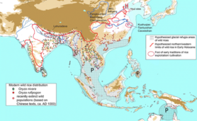
The first goal is a literature study to create a database with historical rice growing areas. The temporal and spatial focus is open for discussion: in principle the Holocene period; and varying from the Euphrates/Tigris region, Egypt, India, China but also rest of Asia, the Americas and Europe, see figure.
Contact: dr. ir. Kees Klein Goldewijk (c.g.m.kleingoldewijk@uu.nl), Vening Meinesz A, room 8.22
References
Klein Goldewijk, K., Beusen, A., Doelman, J., Stehfest, E. (2017) Anthropogenic land-use estimates for the Holocene – HYDE 3.2. Earth Syst. Sci. Data 9, 927 – 953.
Siebert, S., Kummu, M., Porkka, M., Döll, P., Ramankutty, N., Scanlon, B.R. (2015) A global data set of the extent of irrigated land from 1900 to 2005. Hydrol. Earth Syst. Sci. 19, 1521-1545.
Shifting cultivation
Shifting cultivation (SC) is notoriously difficult to model. There are hardly any official statistics kept of the quantity and location of shifting cultivation at present, let alone for the past. And yet, SC has played an important role in past land use practices.
Knowledge of the extent of SC is important for hydrological-, crop-, and integrated assessments modelling (IAM) in global change research. However, current historical global land use reconstructions such as the HYDE database (Klein Goldewijk et al., 2017) which supply directly input for those IAMs, still are struggling to get SC areas in them. It should be included because of their importance for the carbon cycle. Still, information on the historical evolution of SC is limited (Heinimann et al., 2017). Therefore, there is a great demand for historical reconstruction of SC. Important research questions are: How much land was under SC? Where did it take place?
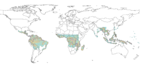
The first goal is a literature study to create a database with historical SC information. The temporal and spatial focus is open for discussion: in principle covering the Holocene period.
Results should be checked against modelling efforts which focus on modeling SC (Heinimann et al., 2017).
Contact: dr. ir. Kees Klein Goldewijk (c.g.m.kleingoldewijk@uu.nl), Vening Meinesz A, room 8.22
References
Heinimann, A., Mertz, O., Frolking, S., Egelund Christensen, A., Hurni, K., Sedano, F., Parsons Chini, L., Sahajpal, R., Hansen, M., Hurtt, G. (2017) A global view of shifting cultivation: Recent, current, and future extent. PLoS ONE 12, e0184479.
Klein Goldewijk, K., Beusen, A., Doelman, J., Stehfest, E. (2017) Anthropogenic land-use estimates for the Holocene – HYDE 3.2. Earth Syst. Sci. Data 9, 927 – 953.
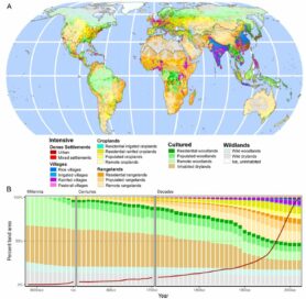
A different way of looking at land use; Anthromes
The Anthromes concept was first developed by (Ellis and Ramankutty, 2008), who introduced the term ‘Anthropogenic Biomes’ or in short ‘Anthromes’ to describe the characterization of terrestrial biomes based on global patterns of sustained, direct human interaction with ecosystems. It was a shift from the classic paradigm that the world consists of ‘natural systems with humans disturbing them’ towards the anthromes paradigm that we live in ‘human systems, with natural systems embedded within them’. They developed a set of rules which were applied to the year 2000. The same approach was extended to a three-hundred year period for 1700 – 2000 CE by Ellis et al. (2010), who used population and land use from the History of the Global Environment (HYDE), version 3.1 as major input (Klein Goldewijk et al., 2011). Since HYDE 3.1 did not provide irrigation and rice as standard input, these data were retrieved from other sources, introducing more uncertainty and inconsistencies.
A recent study by Ellis et al. (2020) applied the anthromes concept upon the new HYDE database, version 3.2. (Klein Goldewijk et al., 2017). HYDE is and internally consistent combination of updated historical population estimates and improved allocation algorithms with time-dependent weighting maps for land use for the Holocene, defined here as 10,000 BCE – 2015 CE. Categories include cropland, with a new distinction into irrigated and rain fed crops (other than rice) and irrigated and rain fed rice. Also grazing lands are provided, divided into more intensively used pasture and less intensively used rangeland. Population is also represented by maps of total, urban, rural population and population density as well as built-up area.
The first goal is to study different regions in the world of how land use evolves over time. What are the similarities and differences between regions? Did agriculture expand, intensify, involute or collapse over time? Results should be checked against existing theories about regime shifts mechanisms (ecological, technological, or economical).
Contact: dr. ir. Kees Klein Goldewijk (c.g.m.kleingoldewijk@uu.nl), Vening Meinesz A, room 8.22
References for all proposals.
Ellis, E.C., Beusen, A.H.W., Goldewijk, K.K. (2020) Anthropogenic Biomes: 10,000 BCE to 2015 CE. LAND 9, 129.
Ellis, E.C., Klein Goldewijk, K., Siebert, S., Lightman, D., Ramankutty, N. (2010) Anthropogenic transformation of the biomes, 1700 to 2000. Global Ecology and Biogeography 19, 589-606.
Ellis, E.C., Ramankutty, N. (2008) Putting people in the map: Anthropogenic biomes of the world. Frontiers in Ecology and the Environment 6, 439-447.
Heinimann, A., Mertz, O., Frolking, S., Egelund Christensen, A., Hurni, K., Sedano, F., Parsons Chini, L., Sahajpal, R., Hansen, M., Hurtt, G. (2017) A global view of shifting cultivation: Recent, current, and future extent. PLoS ONE 12, e0184479.
Hurtt, G.C., Chini, L., Sahajpal, R., Frolking, S., Bodirsky, B.L., Calvin, K., Doelman, J.C., Fisk, J., Fujimori, S., Goldewijk, K.K., Hasegawa, T., Havlik, P., Heinimann, A., Humpenöder, F., Jungclaus, J., Kaplan, J., Kennedy, J., Kristzin, T., Lawrence, D., Lawrence, P., Ma, L., Mertz, O., Pongratz, J., Popp, A., Poulter, B., Riahi, K., Shevliakova, E., Stehfest, E., Thornton, P., Tubiello, F.N., van Vuuren, D.P., Zhang, X. (2020) Harmonization of Global Land-Use Change and Management for the Period 850-2100 (LUH2) for CMIP6. Geosci. Model Dev. Discuss. 2020, 1-65.
Klein Goldewijk, K., Beusen, A., Doelman, J., Stehfest, E. (2017) Anthropogenic land-use estimates for the Holocene – HYDE 3.2. Earth Syst. Sci. Data 9, 927 – 953.
Klein Goldewijk, K., Beusen, A., van Drecht, G., de Vos, M. (2011) The HYDE 3.1 spatially explicit database of human induced land use change over the past 12,000 years. Global Ecology and Biogeography 20, 73-86.
Klein Goldewijk, K., Verburg, P.H. (2013) Uncertainties in global-scale reconstructions of historical land use: an illustration using the HYDE data set. Landscape Ecology 28, 861-877.
Ma, L., Hurtt, G.C., Chini, L.P., Sahajpal, R., Pongratz, J., Frolking, S., Stehfest, E., Klein Goldewijk, K., O’Leary, D., Doelman, J.C. (2020) Global rules for translating land-use change (LUH2) to land-cover change for CMIP6 using GLM2. Geosci. Model Dev. 13, 3203-3220.
Siebert, S., Kummu, M., Porkka, M., Döll, P., Ramankutty, N., Scanlon, B.R. (2015) A global data set of the extent of irrigated land from 1900 to 2005. Hydrol. Earth Syst. Sci. 19, 1521-1545.
I also welcome students that are interested in:
- How to use and implement archaeological data and/or paleo-ecological data into HYDE? Can we define rules for land use allocation that mimic historical patterns, based on physical parameters or socio-ecological behaviour?
- Can we quantify the hunters/gatherers part of the population over the Holocene (to be implemented in HYDE)
- Investigate the role of land use change and biodiversity over time
- Investigate the HYDE allocation rules for a specific country